Through a partnership with multiple state and federal agencies, the Wisconsin Department of Agriculture, Trade and Consumer Protection (DATCP) will use airborne electromagnetic (AEM) technology to measure the depth to bedrock in areas of northeastern Wisconsin. A low-flying helicopter will tow a magnetic sensor that will provide accurate science-based data about below ground properties to update depth to bedrock maps. Knowing how deep the soil is before reaching bedrock is key to understanding how to protect groundwater from potential pollutants applied on the surface. The U.S. Geological Survey (USGS) is leading the project, with collaboration from the Wisconsin Department of Natural Resources (DNR), the Wisconsin Geological and Natural History Survey (WGNHS), and DATCP.
“This project will update our maps and help landowners better understand how surface applications of certain materials can impact groundwater quality,” said Sara Walling, Administrator of DATCP’s Division of Agricultural Resource Management. “Protecting Wisconsin’s groundwater is essential to public health and to the state’s economy. We all rely on clean groundwater for drinking, irrigating crops, watering livestock, and processing foods.”
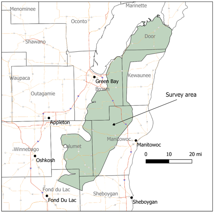
Depending on weather and flight conditions, DATCP anticipates surveying to begin in early January, with the helicopter flying over the following counties: Brown, Calumet, Door, Fond du Lac, Kewaunee, Manitowoc, and Sheboygan. The helicopter will fly in a grid pattern, with half-mile spacing between flight lines. To ensure data accuracy, flight measurements will be compared against a three-mile control line of on-the-ground measurements taken by WGNHS. Currently, the project focuses on several counties with Silurian bedrock. Silurian bedrock is composed of highly fractured dolomite that allows materials to pass through it more easily to reach groundwater quicker.
By updating depth to bedrock maps, the project will reduce the financial burden on private landowners to verify existing maps, and produce data that will enhance the understanding of below ground properties in order to improve groundwater quality. Results of the survey will be made public once available.
To learn more about this project, visit https://aemsurvey.wi.gov.